v8.3.0flutter_map
Der Nr. 1 nichtkommerziell ausgerichtete Kartenclient für Flutter: einfach zu bedienen, vielseitig, anbieterunabhängig, vollständig plattformübergreifend und 100 % rein Flutter
App zur Erfassung von barrierefreien Daten im öffentlichen Nahverkehr gemäß OpenStreetMap-Vorgaben
v8.3.0Der Nr. 1 nichtkommerziell ausgerichtete Kartenclient für Flutter: einfach zu bedienen, vielseitig, anbieterunabhängig, vollständig plattformübergreifend und 100 % rein Flutter
Flutter-Integration für MobX. Es bietet eine Reihe von Observer-Widgets, die sich automatisch neu erstellen, wenn die verfolgten Observables sich ändern.
MobX ist eine Bibliothek zur reaktiven Verwaltung des Zustands Ihrer Anwendungen. Nutzen Sie die Kraft von Observables, Aktionen und Reaktionen, um Ihre Dart- und Flutter-Apps zu verbessern.
Geolokations-Plugin für Flutter. Dieses Plugin bietet eine plattformübergreifende (iOS, Android) API für allgemeine Ortsfunktionen (GPS usw.).
Eine Vektor-Mathematik-Bibliothek für 2D- und 3D-Anwendungen.
Ein Paket zum Bearbeiten von Stacktraces und deren lesbaren Ausgabe.
Flutter-Plugin zur Authentifizierung eines Benutzers mit einem Webdienst.
Ein schmaler, aber leistungsstarker Caching-Plugin für Tile-Ebenen von flutter_map.
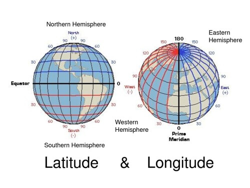
v0.10.1Leichte Bibliothek für gängige Berechnungen von Breite und Länge
Ein Builder zum Extrahieren einer Paketversion in den Code.
HTTP-Anfrage-Mocking-Bibliothek für Dart und Flutter. Testen Sie Ihre Anwendung isoliert.
Ein schneller Algorithmus zur Bestimmung des Inaccessibility-Polys eines Polygons, implementiert als Dart-Bibliothek. Nützlich für die optimale Platzierung eines Textlabels auf einem Polygon.
{"sdk":"flutter"}{"sdk":"flutter"}^8.1.1^2.0.0+1^2.0.1^2.1.5^14.0.2^0.9.0^2.1.4^1.0.1^3.1.0{"git":{"url":"https://github.com/OPENER-next/animated_location_indicator.git"}}{"git":{"url":"https://github.com/OPENER-next/animated_marker_layer.git"}}{"git":{"url":"https://github.com/OPENER-next/osm_api.git"}}{"git":{"url":"https://github.com/OPENER-next/temaki_flutter.git"}}{"git":{"url":"https://github.com/OPENER-next/offline_geocoder.git"}}^1.17.0^5.1.0^2.5.5^11.1.0^6.0.17^5.1.0^3.1.0+7447^1.0.5{"git":{"url":"https://github.com/Robbendebiene/flutter-mvvm-architecture.git","ref":"cdbfec0bec66614abfbd154850a735dd0b026888"}}^7.6.0^2.2.0^2.0.6+5^0.7.1^8.0.0any^2.13.1{"sdk":"flutter"}^0.14.1^6.0.0^1.2.1^1.11.0^2.6.0^2.1.1Englischer Projektschnappschuss. Aktuelle Inhalte auf GitHub.
OpenStop
The goal of this app is to collect accessibility data for public transport stops in OpenStreetMap so that everyone can benefit from it. Due to the huge amount of public transport stops out there we want to encourage all citizen (experienced OSM users and newcomers) to help gathering this data. That's why we are developing this app that allows collecting the data in an easy, accessible and safe manner by asking simple questions. For deeper insight read the working principle of the app.
The data shall be the foundation for better routing especially for impaired people and lead to a renovation of non accessible stops, as well as many other things we ourselves can't even imagine right now.
Thanks and happy mapping!
Get it on Google Play Download on the App Store Get it on F-Droid
Screenshot with map overview Screenshot with visualized POI Screenshot with multiple choice question dialog Screenshot with bool question dialog and extended info box Screenshot with summary and upload dialog
We are always happy, if you not only want to help us mapping, but also want to directly participate in the project.
You can either open issues for enhancement suggestions and bug reports or help us developing the app further. A good starting point for the latter is to read the build instructions for the app.
You can also help translating the app at Weblate.
This app is released under the terms of the GNU General Public License v3.0 or later (GPL-3.0-or-later).
Logo of the German Federal Ministry of Digital Affairs and Transport Logo of the mFUND innovation initiative
OpenStop is developed in the project OPENER next, which is funded by the German Federal Ministry for Digital and Transport as part of the mFUND innovation initiative.
Special thanks to Andy Allan (@gravitystorm) for granting us free access to the beautiful Thunderforest map tiles.