
 v2.2.5
geojson_vi
RFC 7946 के अनुरूप जियोजेसन डेटा को प्रभावी ढंग से हैंडल करने के लिए एक खुला स्रोत डार्ट और फ्लटर लाइब्रेरी
66लाइक 20.7 हज़ार30-दिन डाउनलोड150Pub अंक
AndroidiOSWebmacOSWindowsLinux
RFC 7946 के अनुरूप जियोजेसन डेटा को प्रभावी ढंग से हैंडल करने के लिए एक खुला स्रोत डार्ट और फ्लटर लाइब्रेरी

यह अंग्रेज़ी मूल स्नैपशॉट है। नवीनतम सामग्री GitHub पर देखें।
geojson_vi is an open-source library for Dart and Flutter developers, specifically designed to provide comprehensive support for the GeoJSON geospatial data interchange format as per the RFC 7946 standard. The software is a flexible, reliable tool that allows developers to parse, read, create, update, search, and delete geospatial data effectively.
Powerful Tools for Efficient GeoJSON Data Handling. Some of the primary ones include:
GeoJSONPoint, GeoJSONMultiPoint, GeoJSONLineString, GeoJSONMultiLineString, GeoJSONPolygon, GeoJSONMultiPolygon, GeoJSONGeometryCollection), Feature, and FeatureCollection, making it a versatile tool for effectively managing diverse geospatial data.| GeoJSON Class Diagram |
|---|
| Class structure of the geojson_vi library |
| GeoJSON Geometry Class Diagram |
|---|
| Detailed Class Diagram of GeoJSON Geometry in the geojson_vi library |
  final map = {
    'type': 'Point',
    'coordinates': [105.77389, 21.0720414]
  };

  final jsonString =
      '{"type": "Point", "coordinates": [105.78070163726807, 21.067921688241626]}';

  final polygonCoordinates = [
    [
      [104.765625, 20.468189],
      [106.545410, 20.468189],
      [106.545410, 21.596150],
      [104.765625, 21.596150],
      [104.765625, 20.468189]
    ]
  ];

  // Creating a GeoJSON object from data without knowing its type
  final pointFromMap = GeoJSON.fromMap(map);

  // Creating a GeoJSONPoint object from a JSON string when the type is known
  final pointFromJSON = GeoJSONPoint.fromJSON(jsonString);

  // Creating a GeoJSONGeometry object from data without knowing its type
  final geometryFromMap = GeoJSONGeometry.fromMap(map);

  // Creating a GeoJSONPoint object from a JSON string when the type is known
  final geometryFromJSON = GeoJSONPoint.fromJSON(jsonString);

  // Creating a GeoJSONPoint object from coordinates data
  final pointFromCoordinates = GeoJSONPoint([105.77389, 21.0720414]);

  // Creating a GeoJSONFeature object
  final feature = GeoJSONFeature(
    GeoJSONPoint([105.780701, 21.067921]),
    properties: {
      'title': 'Hanoi University of Mining and Geology',
      'url': 'http://humg.edu.vn',
    },
  );

  // Creating a GeoJSONFeatureCollection object
  final featureCollection = GeoJSONFeatureCollection([]);
  featureCollection.features.add(feature);

  // Creating more GeoJSONFeature
  final polygon = GeoJSONPolygon(polygonCoordinates);
  final polygonFeature = GeoJSONFeature(polygon);
  featureCollection.features.add(polygonFeature);
import 'package:geojson_vi/geojson_vi.dart';

void main() {
  final featureCollection = GeoJSONFeatureCollection([]);
  final point = GeoJSONPoint([105.7743099, 21.0717561]);
  final feature = GeoJSONFeature(point, properties: {
    'marker-color': '#7e7e7e',
    'marker-size': 'medium',
    'marker-symbol': 'college',
    'title': 'Hanoi University of Mining and Geology',
    'department': 'Geoinformation Technology',
    'address':
        'No.18 Vien Street - Duc Thang Ward - Bac Tu Liem District - Ha Noi, Vietnam',
    'url': 'http://humg.edu.vn'
  });
  featureCollection.features.add(feature);
  final pos1 = [105.7771289, 21.0715458];
  final pos2 = [105.7745218, 21.0715658];
  final pos3 = [105.7729125, 21.0715358];
  final lineString = GeoJSONLineString([pos1, pos2, pos3]);
  featureCollection.features.add(GeoJSONFeature(lineString, properties: {
    'stroke': '#7e7e7e',
    'stroke-width': 2,
    'stroke-opacity': 1,
    'title': 'Vien St.'
  }));
  final p01 = [105.7739666, 21.0726795]; // The first position
  final p02 = [105.7739719, 21.0721991];
  final p03 = [105.7743394, 21.0721966];
  final p04 = [105.7743310, 21.0725269];
  final p05 = [105.7742564, 21.0726120];
  final p06 = [105.7741865, 21.0726095];
  final p07 = [105.7741785, 21.0726746];
  final p08 = [105.7739666, 21.0726795]; // The last position
  final linerRing = [p01, p02, p03, p04, p05, p06, p07, p08];
  featureCollection.features.add(
    GeoJSONFeature(
      GeoJSONPolygon([linerRing]),
      properties: {
        'stroke': '#555555',
        'stroke-width': 2,
        'stroke-opacity': 1,
        'fill': '#ab7942',
        'fill-opacity': 0.5,
        'title': "HUMG's Office"
      },
    ),
  );
  print(featureCollection.toJSON());
}
Output: new.geojson
{
  "type": "FeatureCollection",
  "features": [
    {
      "type": "Feature",
      "properties": {
        "marker-color": "#7e7e7e",
        "marker-size": "medium",
        "marker-symbol": "college",
        "title": "Hanoi University of Mining and Geology",
        "department": "Geoinformation Technology",
        "address": "No.18 Vien Street - Duc Thang Ward - Bac Tu Liem District - Ha Noi, Vietnam",
        "url": "http://humg.edu.vn"
      },
      "geometry": {
        "type": "Point",
        "coordinates": [
          105.7743099,
          21.0717561
        ]
      }
    },
    {
      "type": "Feature",
      "properties": {
        "stroke": "#7e7e7e",
        "stroke-width": 2,
        "stroke-opacity": 1,
        "title": "Vien St."
      },
      "geometry": {
        "type": "LineString",
        "coordinates": [
          [
            105.7771289,
            21.0715458
          ],
          [
            105.7745218,
            21.0715658
          ],
          [
            105.7729125,
            21.0715358
          ]
        ]
      }
    },
    {
      "type": "Feature",
      "properties": {
        "stroke": "#555555",
        "stroke-width": 2,
        "stroke-opacity": 1,
        "fill": "#ab7942",
        "fill-opacity": 0.5,
        "title": "HUMG's Office"
      },
      "geometry": {
        "type": "Polygon",
        "coordinates": [
          [
            [
              105.7739666,
              21.0726795
            ],
            [
              105.7739719,
              21.0721991
            ],
            [
              105.7743394,
              21.0721966
            ],
            [
              105.774331,
              21.0725269
            ],
            [
              105.7742564,
              21.072612
            ],
            [
              105.7741865,
              21.0726095
            ],
            [
              105.7741785,
              21.0726746
            ],
            [
              105.7739666,
              21.0726795
            ]
          ]
        ]
      }
    }
  ]
}
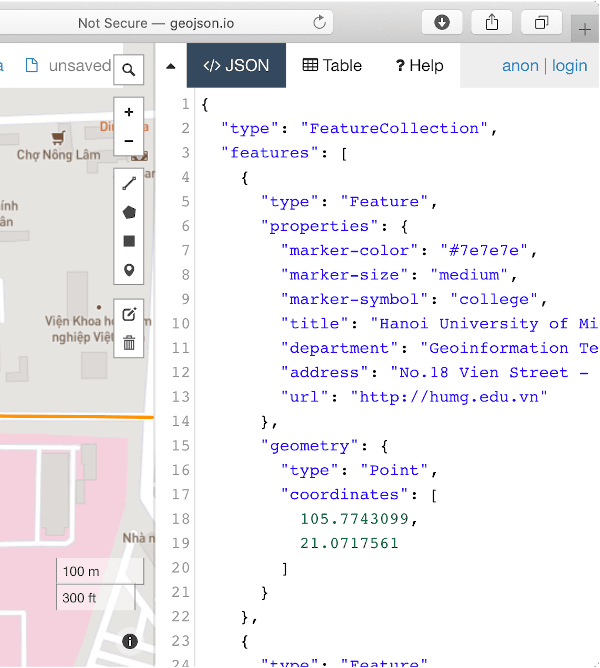
Quick viewing on geojson.io Quick viewing
H. Butler, M. Daly, A. Doyle, S. Gillies, S. Hagen, and T. Schaub, "The GeoJSON Format", August 2016, https://tools.ietf.org/html/rfc7946.
Please file feature requests and bugs at the issue tracker.