搜尋套件、儲存庫與 APP 分類

mapbox_search 封面
套件詳情v4.4.0

mapbox_search

一個用於使用 MapBox API 進行地點搜尋和靜態地圖影像的 Flutter 套件

AndroidiOSWebmacOSWindowsLinux
近 30 天下載
2.2萬
喜歡數
96
Pub 分數
140

安裝套件

flutter pub add mapbox_search

套件介紹

根據套件公開資料產生的選型評估,僅供參考。

一個 Flutter 套件,利用 MapBox API 提供地點搜尋功能並產生靜態地圖影像。它透過提供直觀的介面,簡化了在 Flutter 應用中整合地理定位功能的過程,支援搜尋位置、取得座標以及顯示靜態地圖。非常適合需要地址查詢、位置選擇或地圖預覽的應用程式。此套件支援 Android、iOS、Web、macOS、Windows 與 Linux 多個平台,確保廣泛的相容性。開發者可輕鬆實作基於位置的服務,且設定簡單。

適用情境

  • 移動應用中的位置搜尋
  • 表單地址選擇器
  • 靜態地圖預覽
  • 地理編碼整合
  • 基於地圖的使用者介面元件
  • 旅行與配送應用

主要特色

  • MapBox API 結合
  • 靜態地圖影像產生
  • 跨平台支援
  • 簡單搜尋介面
  • 座標檢索
  • 響應式設計

適合對象

  • 開發位置感知應用的開發者
  • 需要地址查詢的應用
  • 需要靜態地圖的專案
  • 跨平台行動與網頁應用程式
  • 旅行、物流與地圖工具

使用建議

  • 需要 MapBox API 金鑰
  • 需要網絡連接
  • 免費層級上的潛在速率限制
  • 搜尋UI的自訂選項有限
  • 依賴外部API的穩定性
  • 每個平台的額外設定

原始 README

以下為關聯原始碼儲存庫的 README 原文快照,最新內容請造訪原始碼儲存庫。

Pub

About

Note: Breaking Changes in 4.x.x

  • PlaceSearch and ReverseGeoCoding classes are now merged into one class called GeoCoding with two methods getPlaces and getAddress since both of them are using the same API.
  • MapBox's new SearchBox API is added to the package.
  • Instead of throwing exceptions, the package now returns ApiResponse Record which can be either Success or Failure and can be handled using fold method.
  • Location class is now converted to a record.
  • List of coordinates are now converted to a record (lat: double, long: doube) whereever possible.

This package provides easy api calls to MapBox Search API.

Also, it contains an static map image generator.

Maki Icons can be used now in marker icon

As this package doesn't depend on Flutter SDK you cannot use the Colors class anymore on you Flutter project. Instead use map_box_search's Color.rgb constructor, passing the values as parameters:

var myColor = Colors.redAccent; //Flutter's Color class
var mapBoxColor = Color.rgb( myColor.red, myColor.green, myColor.blue);

Installing

First of all you must acquire an API key on the MapBox website https://www.mapbox.com/

Then, add the following to your pubspec.yaml file:

dependencies:
  mapbox_search: any

Setup

Now you can setup the API key for whole app by calling MapBoxSearch.init('API KEY') in your main() function, this way you don't have to pass the API key to every class that uses the package.

Usage of ApiResponse
final ApiResponse<List<MapBoxPlace>> addresses = await getAddress();
addresses.fold(
    (success) => // Do something with success data,
    (failure) => // Do something with failure data,
  );

Examples

SearchBox API
SearchBoxAPI search = SearchBoxAPI(
      apiKey: 'API Key', // dont pass if you have set it in MapBoxSearch.init('API KEY')
      limit: 6,
);
Get Suggestions
ApiResponse<SuggestionResponse> searchPlace = await search.getSuggestions(
    "central",
  );
Get mapbox_id
  • From SuggestionResponse
String mapboxId = searchPlace.suggestions[0].mapboxId;
Get Place Details
ApiResponse<RetrieveResonse> searchPlace = await search.getPlace(mapboxId);
Reverse GeoCoding
var reverseGeoCoding = GeoCoding(
    apiKey: 'API Key', // dont pass if you have set it in MapBoxSearch.init('API KEY')
    limit: 5,
);

Future<ApiResponse<List<MapBoxPlace>>> getAddress() =>
  reverseGeoCoding.getAddress(
    Location(lat: 72.0, lng: 76.00),
);
Forward GeoCoding Seach
var geocoding = GeoCoding(
    apiKey: 'API Key', // dont pass if you have set it in MapBoxSearch.init('API KEY')
    country: "BR",
    limit: 5,
    types: [PlaceType.address, PlaceType.place],
);

Future<ApiResponse<List<MapBoxPlace>>> getPlaces() =>
  geocoding.getPlaces(
      "central park",
      proximity: Location(
        lat: -19.984634,
        lng: -43.9502958,
      ),
    );
Batch Geocoding (v6)

Perform multiple geocoding queries (forward, reverse, or structured) in a single request.

var geocoding = GeoCodingApiV6(
    apiKey: 'API Key', // or use MapBoxSearch.init('API KEY')
    limit: 5,
);

Future<ApiResponse<BatchGeocodingResponse>> getBatch() =>
  geocoding.batch([
    ForwardQuery(query: "Eiffel Tower", limit: 1),
    ReverseQuery(location: (lat: 40.6892, long: -74.0445), limit: 1),
  ]);
Static Image
StaticImage staticImage = StaticImage(
    apiKey: 'API Key', // or use MapBoxSearch.init('API KEY')
  );
Image With Polyline
    String getStaticImageWithPolyline() => staticImage.getStaticUrlWithPolyline(
      point1: (lat: 37.77343, long: -122.46589),
      point2: (lat: 37.75965, long: -122.42816),
      marker1: MapBoxMarker( markerColor: const RgbColor(0, 0, 0),
          markerLetter: 'p',
          markerSize: MarkerSize.LARGE),
      marker2: MapBoxMarker(
          markerColor: const RgbColor(244, 67, 54),
          markerLetter: 'q',
          markerSize: MarkerSize.SMALL),
      height: 300,
      width: 600,
      zoomLevel: 15.5,
      style: MapBoxStyle.Dark,
      path: MapBoxPath(pathColor: const RgbColor(255, 0, 0), pathOpacity: 0.5, pathWidth: 5, pathPolyline: "%7DrpeFxbnjVsFwdAvr%40cHgFor%40jEmAlFmEMwM_FuItCkOi%40wc%40bg%40wBSgM"),
      render2x: true,
      center: (lat: 37.766541503617475, long: -122.44702324243272), // Required when auto is false
      // auto: true, // Alternatively, use auto: true to automatically fit markers and path
    );
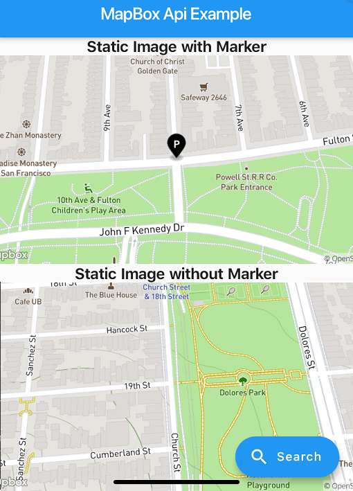
Image with Marker
String getStaticImageWithMarker() => staticImage.getStaticUrlWithMarker(
  center: (lat: 37.77343, long: -122.46589),
  marker: MapBoxMarker(
      markerColor: const RgbColor(0, 0, 0), markerLetter: 'p', markerSize: MarkerSize.LARGE),
  height: 300,
  width: 600,
  zoomLevel: 16,
  style: MapBoxStyle.Streets,
  render2x: true,
);
Image without Marker
String getStaticImageWithoutMarker() => staticImage.getStaticUrlWithoutMarker(
    center: (lat: 37.75965, long: -122.42816),
    height: 300,
    width: 600,
    zoomLevel: 16,
    style: MapBoxStyle.Outdoors,
    render2x: true,
  );
Example App

Check out the example/ directory for a complete Flutter application demonstrating:

  • Forward & Reverse Geocoding
  • Batch Geocoding
  • Static Images (Markers, Polylines, Auto-framing)

所屬分類

依賴

依賴清單 5 項

原始碼儲存庫

使用此套件的專案