パッケージ、リポジトリ、アプリカテゴリを検索

mapbox_search のカバー
パッケージ詳細v4.4.0

mapbox_search

MapBox API を使用した場所検索および静的マップ画像用のFlutterパッケージ

AndroidiOSWebmacOSWindowsLinux
30日間ダウンロード
2.2万
いいね数
96
Pub ポイント
140

パッケージをインストール

flutter pub add mapbox_search

パッケージ概要

公開情報に基づく選定ガイドです。参考としてご利用ください。

MapBox API を使用して場所検索機能を有効にする Flutter パッケージであり、静的マップ画像を生成します。場所の検索、座標の取得、静的マップの表示に向けたシンプルなインターフェースを提供することで、Flutter アプリへの地理情報機能の統合を容易にします。住所検索、場所選択、マッププレビューが必要なアプリケーションに最適です。Android、iOS、Web、macOS、Windows、Linux など複数のプラットフォームをサポートしており、広範な互換性を確保しています。開発者は最小限のセットアップで位置ベースのサービスを簡単に実装できます。

用途

  • モバイルアプリにおける場所検索
  • フォーム用の住所ピッカー
  • 静的マッププレビュー
  • ジオコーディングの統合
  • マップベースのUIコンポーネント
  • 旅行および配達アプリ

主な機能

  • MapBox API の統合
  • 静的マップ画像の生成
  • クロスプラットフォーム対応
  • シンプルな検索インターフェース
  • 座標の取得
  • レスポンシブデザイン

適している対象

  • 場所に応じたアプリを開発する開発者
  • 住所検索が必要なアプリ
  • 静的マップを必要とするプロジェクト
  • クロスプラットフォームのモバイルおよびウェブアプリ
  • 旅行、物流およびマッピングツール

注意事項

  • MapBox API キーが必要です
  • ネットワーク接続が必要です
  • 無料トライアルでの潜在的なレート制限
  • 検索UIのカスタマイズが限定的
  • 外部APIの安定性に依存
  • 各プラットフォーム用の追加構成

元の README

関連するソースリポジトリの README 原文のスナップショットです。最新の内容はリポジトリをご覧ください。

Pub

About

Note: Breaking Changes in 4.x.x

  • PlaceSearch and ReverseGeoCoding classes are now merged into one class called GeoCoding with two methods getPlaces and getAddress since both of them are using the same API.
  • MapBox's new SearchBox API is added to the package.
  • Instead of throwing exceptions, the package now returns ApiResponse Record which can be either Success or Failure and can be handled using fold method.
  • Location class is now converted to a record.
  • List of coordinates are now converted to a record (lat: double, long: doube) whereever possible.

This package provides easy api calls to MapBox Search API.

Also, it contains an static map image generator.

Maki Icons can be used now in marker icon

As this package doesn't depend on Flutter SDK you cannot use the Colors class anymore on you Flutter project. Instead use map_box_search's Color.rgb constructor, passing the values as parameters:

var myColor = Colors.redAccent; //Flutter's Color class
var mapBoxColor = Color.rgb( myColor.red, myColor.green, myColor.blue);

Installing

First of all you must acquire an API key on the MapBox website https://www.mapbox.com/

Then, add the following to your pubspec.yaml file:

dependencies:
  mapbox_search: any

Setup

Now you can setup the API key for whole app by calling MapBoxSearch.init('API KEY') in your main() function, this way you don't have to pass the API key to every class that uses the package.

Usage of ApiResponse
final ApiResponse<List<MapBoxPlace>> addresses = await getAddress();
addresses.fold(
    (success) => // Do something with success data,
    (failure) => // Do something with failure data,
  );

Examples

SearchBox API
SearchBoxAPI search = SearchBoxAPI(
      apiKey: 'API Key', // dont pass if you have set it in MapBoxSearch.init('API KEY')
      limit: 6,
);
Get Suggestions
ApiResponse<SuggestionResponse> searchPlace = await search.getSuggestions(
    "central",
  );
Get mapbox_id
  • From SuggestionResponse
String mapboxId = searchPlace.suggestions[0].mapboxId;
Get Place Details
ApiResponse<RetrieveResonse> searchPlace = await search.getPlace(mapboxId);
Reverse GeoCoding
var reverseGeoCoding = GeoCoding(
    apiKey: 'API Key', // dont pass if you have set it in MapBoxSearch.init('API KEY')
    limit: 5,
);

Future<ApiResponse<List<MapBoxPlace>>> getAddress() =>
  reverseGeoCoding.getAddress(
    Location(lat: 72.0, lng: 76.00),
);
Forward GeoCoding Seach
var geocoding = GeoCoding(
    apiKey: 'API Key', // dont pass if you have set it in MapBoxSearch.init('API KEY')
    country: "BR",
    limit: 5,
    types: [PlaceType.address, PlaceType.place],
);

Future<ApiResponse<List<MapBoxPlace>>> getPlaces() =>
  geocoding.getPlaces(
      "central park",
      proximity: Location(
        lat: -19.984634,
        lng: -43.9502958,
      ),
    );
Batch Geocoding (v6)

Perform multiple geocoding queries (forward, reverse, or structured) in a single request.

var geocoding = GeoCodingApiV6(
    apiKey: 'API Key', // or use MapBoxSearch.init('API KEY')
    limit: 5,
);

Future<ApiResponse<BatchGeocodingResponse>> getBatch() =>
  geocoding.batch([
    ForwardQuery(query: "Eiffel Tower", limit: 1),
    ReverseQuery(location: (lat: 40.6892, long: -74.0445), limit: 1),
  ]);
Static Image
StaticImage staticImage = StaticImage(
    apiKey: 'API Key', // or use MapBoxSearch.init('API KEY')
  );
Image With Polyline
    String getStaticImageWithPolyline() => staticImage.getStaticUrlWithPolyline(
      point1: (lat: 37.77343, long: -122.46589),
      point2: (lat: 37.75965, long: -122.42816),
      marker1: MapBoxMarker( markerColor: const RgbColor(0, 0, 0),
          markerLetter: 'p',
          markerSize: MarkerSize.LARGE),
      marker2: MapBoxMarker(
          markerColor: const RgbColor(244, 67, 54),
          markerLetter: 'q',
          markerSize: MarkerSize.SMALL),
      height: 300,
      width: 600,
      zoomLevel: 15.5,
      style: MapBoxStyle.Dark,
      path: MapBoxPath(pathColor: const RgbColor(255, 0, 0), pathOpacity: 0.5, pathWidth: 5, pathPolyline: "%7DrpeFxbnjVsFwdAvr%40cHgFor%40jEmAlFmEMwM_FuItCkOi%40wc%40bg%40wBSgM"),
      render2x: true,
      center: (lat: 37.766541503617475, long: -122.44702324243272), // Required when auto is false
      // auto: true, // Alternatively, use auto: true to automatically fit markers and path
    );
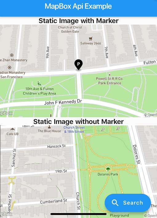
Image with Marker
String getStaticImageWithMarker() => staticImage.getStaticUrlWithMarker(
  center: (lat: 37.77343, long: -122.46589),
  marker: MapBoxMarker(
      markerColor: const RgbColor(0, 0, 0), markerLetter: 'p', markerSize: MarkerSize.LARGE),
  height: 300,
  width: 600,
  zoomLevel: 16,
  style: MapBoxStyle.Streets,
  render2x: true,
);
Image without Marker
String getStaticImageWithoutMarker() => staticImage.getStaticUrlWithoutMarker(
    center: (lat: 37.75965, long: -122.42816),
    height: 300,
    width: 600,
    zoomLevel: 16,
    style: MapBoxStyle.Outdoors,
    render2x: true,
  );
Example App

Check out the example/ directory for a complete Flutter application demonstrating:

  • Forward & Reverse Geocoding
  • Batch Geocoding
  • Static Images (Markers, Polylines, Auto-framing)

カテゴリー

依存関係

依存関係一覧 5 件

ソースリポジトリ

このパッケージを使用しているプロジェクト