पैकेज, रिपॉज़िटरी और ऐप श्रेणियाँ खोजें

fluster कवर
पैकेज विवरणv1.2.0

fluster

Dart के लिए भौगोलिक बिंदु समूहन पुस्तकालय, मानचित्र समाधान में मार्कर के बीच अंतर को सुविधाजनक बनाने में मदद करता है।

AndroidiOSWebmacOSWindowsLinux
30-दिन डाउनलोड
14.3 हज़ार
लाइक
134
Pub अंक
150

पैकेज इंस्टॉल करें

flutter pub add fluster

पैकेज अवलोकन

सार्वजनिक जानकारी से बना चयन मार्गदर्शन। केवल संदर्भ हेतु।

Fluster एक जियोस्पेशियल पॉइंट क्लस्टरिंग लाइब्रेरी है जो डार्ट में बनाई गई है, जिसका उपयोग मानचित्र एप्लिकेशन में मार्कर को समूहित और प्रबंधित करने के लिए किया जाता है। यह ज़ूम स्तर और स्थानिक निकटता के आधार पर बिंदुओं को डायनामिक रूप से समूहित करके मार्कर के अत्यधिक घनत्व को रोकता है। बड़े डेटासेट वाले मानचित्र में प्रदर्शन अनुकूलन के लिए उपयुक्त, Fluster प्लेटफॉर्म के आधार पर चलने वाले उपयोगकर्ता अनुभव को सुगम बनाता है। लाइब्रेरी फ्लटर ऐप्स में आसानी से एकीकृत होती है और एंड्रॉइड, आईओएस, वेब, मैकओएस, विंडोज और लिनक्स जैसे विभिन्न प्लेटफॉर्म को समर्थन देती है।

उपयोग

  • बड़े पैमाने पर मानचित्र चिह्न दृश्यकरण
  • घने डेटा के साथ रियल-टाइम स्थान ट्रैकिंग
  • मैपिंग यूआई में प्रदर्शन अनुकूलन
  • ज़ूम स्तर के आधार पर डायनामिक क्लस्टरिंग
  • मैप-आधारित विश्लेषण डैशबोर्ड

मुख्य विशेषताएँ

  • प्रभावी स्थानिक क्लस्टरिंग एल्गोरिथ्म
  • ज़ूम-स्तर अनुकूलित क्लस्टरिंग
  • क्रॉस-प्लेटफॉर्म समर्थन (Android, iOS, Web, macOS, Windows, Linux)
  • हल्का और तेज प्रोसेसिंग
  • Flutter मानचित्र विजेट्स के साथ आसान एकीकरण

इनके लिए उपयुक्त

  • इंटरैक्टिव मानचित्र बना रहे डेवलपर्स
  • उच्च घनत्व स्थान डेटा वाले ऐप्स
  • स्थान-आधारित सेवाओं को प्रदर्शन की आवश्यकता होती है
  • Google Maps या समान प्लगइन का उपयोग करने वाले Flutter विकासकर्ता
  • स्केलेबल मार्कर प्रबंधन की आवश्यकता वाले प्रोजेक्ट

विचार योग्य बातें

  • स्थिर या आधा-स्थिर डेटासेट के लिए सबसे उपयुक्त
  • बहुत उच्च-आवृत्ति अपडेट के लिए ट्यूनिंग की आवश्यकता हो सकती है
  • बिंदु समूहन (बहुभुज या रेखा विशेषताओं के अलावा) सीमित
  • सटीक निर्देशांक इनपुट पर निर्भर करता है
  • ऑफलाइन क्लस्टरिंग परिदृश्य के लिए अनअप्टीमाइज़्ड

मूल README

संबंधित सोर्स रिपॉज़िटरी के मूल README का स्नैपशॉट। नवीनतम सामग्री के लिए रिपॉज़िटरी देखें।

Build Status Pub

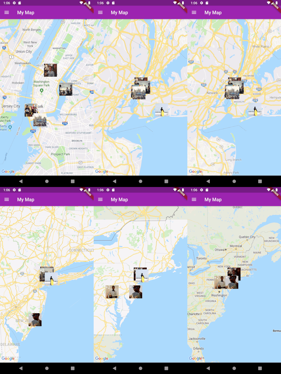
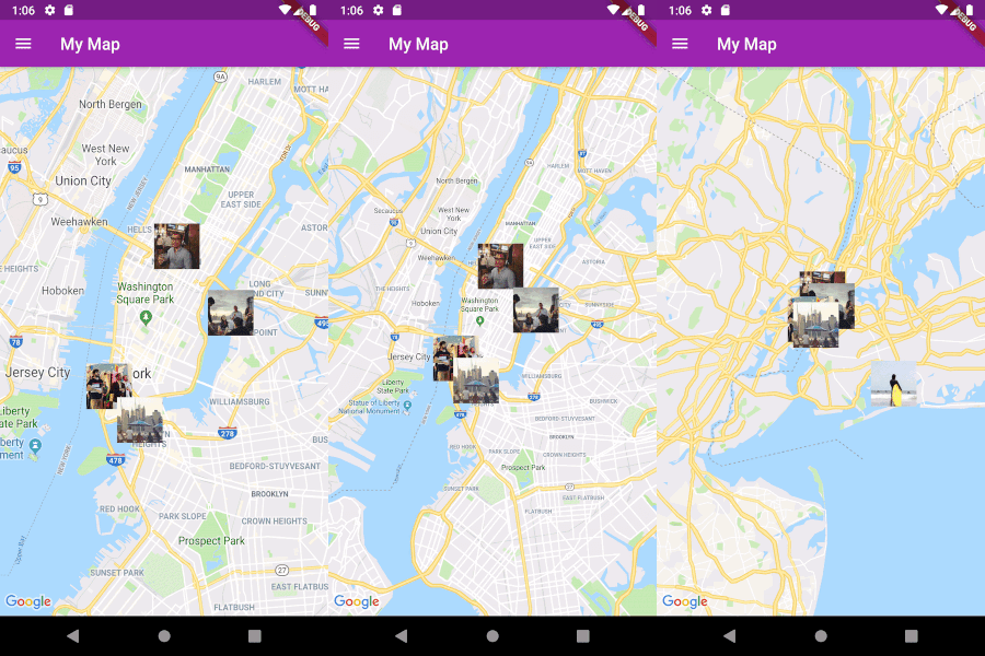
Fluster = Flutter + Cluster

A geospatial point clustering library for Dart (Flutter not actually required). The algorithm is a Dart port of supercluster.

Image

Usage

Implement Clusterable

Fluster will cluster a List of objects that conform to the Clusterable abstract class, which includes necessary information such as latitude and longitude:

class MapMarker extends Clusterable {
  String locationName;
  String thumbnailSrc;

  MapMarker(
      {this.locationName,
      latitude,
      longitude,
      this.thumbnailSrc,
      isCluster = false,
      clusterId,
      pointsSize,
      markerId,
      childMarkerId})
      : super(
            latitude: latitude,
            longitude: longitude,
            isCluster: isCluster,
            clusterId: clusterId,
            pointsSize: pointsSize,
            markerId: markerId,
            childMarkerId: childMarkerId);
}
Set up Fluster

Create a Fluster instance once you have a set of points you'd like to cluster:

List<MapMarker> markers = getMarkers();

Fluster<MapMarker> fluster = Fluster<MapMarker>(
      minZoom: 0,
      maxZoom: 20,
      radius: 150,
      extent: 2048,
      nodeSize: 64,
      points: markers,
      createCluster: (BaseCluster cluster, double longitude, double latitude) {
        return MapMarker(
            markerId: cluster.id.toString(),
            latitude: latitude,
            longitude: longitude);
      });

Parameters:

/// Any zoom value below minZoom will not generate clusters.
int minZoom;

/// Any zoom value above maxZoom will not generate clusters.
int maxZoom;

/// Cluster radius in pixels.
int radius;

/// Adjust the extent by powers of 2 (e.g. 512. 1024, ... max 8192) to get the
/// desired distance between markers where they start to cluster.
int extent;

/// The size of the KD-tree leaf node, which affects performance.
int nodeSize;

/// The List to be clustered.
List<T> points;

/// A callback to generate clusters of the given input type.
T Function(BaseCluster, double, double) createCluster;
Get the clusters

You can then get the clusters for a given bounding box and zoom value, where the bounding box = [southwestLng, southwestLat, northeastLng, northeastLat]:

List<MapMarker> clusters = fluster.clusters([-180, -85, 180, 85], _currentZoom);
Get the cluster children

You can also get the children (points and sub-clusters inside a cluster at the next zoom level, given the cluster id:

List<MapMarker> chilren = fluster.children(int clusterId);
Get the cluster points

Get only the child points (not sub-clusters) of a cluster in all the remaining zoom levels, given the cluster id:

List<MapMarker> points = fluster.points(clusterId);

श्रेणियाँ

सोर्स रिपॉज़िटरी

इस पैकेज का उपयोग करने वाले प्रोजेक्ट